 KL Observer
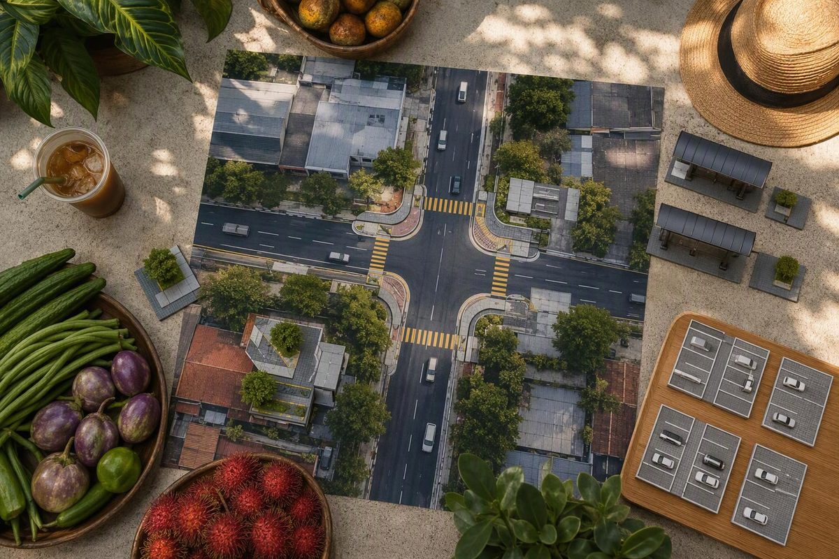
The TTDI Jalan Tun Mohd Fuad crossings make a market-and-meal walk easier to organise: use the raised crossing when changing sides of Jalan Tun Mohd Fuad, and the refuge islands and reported signalised crossing if you continue to the Jalan Datuk Sulaiman junction. Keep the core outing around Jalan Wan Kadir, Jalan Wan Kadir 1 and Jalan Tun Mohd Fuad. Parked vehicles, turning traffic and the bus stop near the raised crossing still require attention; the improvements do not guarantee that an approaching driver will stop.
Choose your next crossing and whether you have a clear view; the tool shows the appropriate action.
Choose Your Next Crossing
Use the raised crossing.
Approach via the pedestrian pathway and check traffic before entering the road. A raised crossing does not guarantee that a driver will stop.
Sources: The Star, 6 December 2024 and 27 July 2026; Malay Mail, 10 February 2026. This is a crossing choice, not a live traffic or accessibility assessment.
The key distinction is between built crossing infrastructure and a proposed parking change. The raised crossing and refuge islands were documented by December 2024. A proposal to convert one traffic lane into legal parking was reported in July 2026. Those reports do not establish that the proposed parking layout was subsequently installed, so do not plan your route around assumed new bays.
The Raised Crossing Is the Main-Road Crossing Point
For a compact outing, the raised crossing on Jalan Tun Mohd Fuad is the relevant piece of infrastructure when your destination is on the opposite side. It provides a designated crossing connected to pedestrian pathways, rather than leaving you to choose a gap between parked vehicles.
The Star’s report dated 6 December 2024 described the raised crossing’s seamless pathway connections and refuge islands at the six-lane-wide Jalan Tun Mohd Fuad–Jalan Datuk Sulaiman junction. The crossing was therefore already documented well before the July 2026 discussion of parking changes. The report described the raised design as encouraging slower driving, not as removing the need to assess traffic. The Star’s 2024 report
| Location | Reported Improvement | Walking Decision |
|---|---|---|
| Jalan Tun Mohd Fuad | Raised crossing with pathway connections | Use it when changing sides |
| Datuk Sulaiman junction | Refuge islands and a signalised crossing | Follow markings and signals |
| Commercial service-road junctions | Kerb extensions and more waiting space | Check for turning vehicles |
These are different crossing situations. A raised crossing serves a change of sides on the main road. Refuge islands provide somewhere to pause while crossing a wide junction. Kerb extensions shorten the distance across service-road junctions and provide more waiting space. None makes it sensible to take a diagonal shortcut through a junction.
If your next shop is on the same side, there is no need to cross simply to use the new infrastructure. Keep the walk direct. If you do need to change sides, approach the designated crossing along the pedestrian route rather than stepping into the road from between parked cars.
The draft’s sources do not give a measured walking distance between the market, the raised crossing and each food stop. This is a route-planning guide, not a promise of a particular walking time or a turn-by-turn map.
The Datuk Sulaiman Junction Is an Optional Extension
The refuge islands at Jalan Datuk Sulaiman are useful when your actual destination takes you across that junction. They are not a reason to extend a market visit farther along Jalan Tun Mohd Fuad, especially when you are carrying shopping in humid weather.
A February 2026 explanation from project partner Global Designing Cities Initiative described a signalised junction crossing, a wheelchair ramp leading to the main road, and later service-road kerb extensions near CelcomDigi and the Mr DIY/24-hour-clinic junction. These are specific access improvements at the locations described. Malay Mail’s project explanation
For a junction crossing, follow the marked route and signals rather than aiming directly at the opposite corner. The islands offer a place to pause across the wide road; they do not establish that every traffic movement is stopped whenever you reach them. Continue to check the traffic relevant to the next part of your crossing.
The reported ramp and pathway connections also do not prove that every shop entrance is accessible, or that the entire market-to-MRT journey is step-free. A wheelchair user or someone pushing a stroller can use the reports to identify useful infrastructure, but should not treat them as a complete accessibility audit. The sources supplied do not document every pavement transition or entrance along the outing.
If your meal and shopping are already complete, finishing within the commercial cluster is a reasonable choice. Add the junction only for a destination you want to reach, with a seated break before continuing if the heat is making the walk uncomfortable.
Start at Pasar Besar TTDI, Then Choose One Meal
Pasar Besar TTDI on Jalan Wan Kadir is the starting anchor for the market portion. Apple Maps lists its hours as 6am–2pm. Treat that as a planning window rather than a guarantee that every stall is open throughout it. A morning visit leaves room to buy what you need and then sit down for a meal, instead of leaving market shopping until close to the listed closing time. Market location and listed hours
Choose the meal destination before deciding whether to cross Jalan Tun Mohd Fuad. That keeps the crossing tied to a real stop, rather than turning the outing into repeated changes of side while you browse. The compact route is market first, one meal next, then either finish or add a smaller stop.
Restoran Ismail at 22 Jalan Tun Mohd Fuad is a useful address anchor, confirmed by the restaurant’s own ordering site. That address identifies a destination; it does not supply a measured route from the market or establish which crossing approach will suit every arrival direction. Use the actual side of the road you are on to decide whether the raised crossing is needed. Restoran Ismail’s store information
Around Jalan Wan Kadir 1 and Jalan Tun Mohd Fuad 1, pay attention to service-road entrances as well as the main road. A widened pavement or kerb extension can make the waiting area clearer while still leaving you exposed to vehicles turning into or out of the commercial streets.
One meal plus one smaller stop fits the pacing of a respectful Kuala Lumpur food crawl. For this particular outing, it also avoids making the Datuk Sulaiman junction an unnecessary extra leg. Take a seated drink break before adding another block, and wait indoors during heavy rain rather than rushing across to keep to a schedule.
T814 Is a Rail Connection, Not a Timed Walking Guarantee
For a rail-led arrival, Rapid KL lists T814 between TTDI MRT station and TTDI, with a published 30-minute frequency. Bring a physical Touch ’n Go card for the feeder bus and leave flexibility for the connection. The published frequency is a planning reference, not a guarantee of your exact departure or arrival time. Rapid KL’s route and payment directory
The supplied route information does not identify a precise alighting stop for this market-and-meal sequence, nor does it provide a measured walk from a stop to the raised crossing. Check your intended stop against your destination instead of assuming that every T814 arrival places you beside the market entrance.
Keep the bus connection separate from the crossing decision. Arriving by feeder bus does not remove the need to check which side of Jalan Tun Mohd Fuad your next destination occupies. Likewise, the presence of a bus stop near the raised crossing is not evidence that the stop serves every leg of your trip.
If the listed market window matters to you, allow room for the bus connection before shopping. Do not build an itinerary that depends on both an exact feeder-bus arrival and every stall remaining open until 2pm. Neither promise is established by the supplied sources.
DBKL’s July Figures Describe Reported Outcomes
In its 17 July 2026 update, DBKL reported pedestrian use up 50%, reaching up to 700 people an hour, and average vehicle speeds falling from 42.5km/h to 30.4km/h. SAYS reported those figures from DBKL’s public post. They are DBKL-reported outcomes for the TTDI improvements, not measurements of every crossing you might make. July findings reported by SAYS
| Measure | DBKL-Reported Figure | What It Does Not Establish |
|---|---|---|
| Pedestrian use | Up 50% | Your individual crossing conditions |
| Pedestrian volume | Up to 700 people/hour | A constant hourly count |
| Average vehicle speed | 42.5 to 30.4km/h | Every driver’s speed or response |
The speed reduction supports the reported purpose of making the street more pedestrian-friendly. An average, however, cannot tell you how fast the next vehicle is travelling or whether its driver has seen you. Use the crossing infrastructure while still judging the immediate traffic situation.
Similarly, “up to 700 people an hour” describes a reported upper volume, not a timetable of busy periods. The supplied reporting does not give enough detail to recommend a quiet crossing hour or calculate your likely waiting time. The market’s listed hours and your chosen meal remain more useful anchors for arranging this outing.
The Parking Proposal Was Disputed, Not Confirmed as Built
On 27 July 2026, The Star reported residents’ objections to a proposal to turn one lane into legal parking. TTDI Residents Association chairman Abu Hafiz Abu Huraira said a DBKL officer had communicated the proposal by WhatsApp. He questioned congestion and where buses would stop at the bus stop just after the raised crossing. July parking-plan report
The same report recorded concerns about fire-engine turns from Jalan Wan Kadir 1. DBKL had not answered the newspaper’s queries by press time. That is a record of objections and an unanswered query at that point, not confirmation that the crossing had failed an emergency-access assessment.
In the February project explanation cited above, GDCI said kerb widths had been reduced following a January fire-truck demonstration to allow large vehicles through. This was the project partner’s account of an adjustment, not an independent safety certification. Keep that distinction alongside the later residents’ concerns rather than treating either account as a complete resolution.
The parking debate was not unanimous. In an August 4 reader letter, TTDI resident Timothy Ong supported formalising parking as a way to bring order and protect pedestrians. A reader’s support for the proposal does not establish that the bays were installed. Ong’s letter
For someone walking to lunch, the practical issue is visibility and usable space on the day. Keep crossing landings and bus boarding space clear. If a parked car or stopped bus hides approaching traffic, wait for a clear view rather than stepping out from behind it. Do not move into the carriageway just to see around the obstruction.
If driving to the market, use designated parking rather than the crossing approach, yellow boxes or bus-stop space. The proposal’s uncertain status is not permission to treat an unmarked traffic lane as a new parking bay. Plan around the crossings that were documented, and judge parking arrangements by the actual signs and markings you find.